 ENEA Antarctic Data Center
Environmental monitoring facilities
Type of resources
Topics
INSPIRE themes
Keywords
Contact for the resource
Provided by
Formats
Representation types
Update frequencies
status
Scale
-
The project aims to determine the mass balance components in the Dome C drainage area and to study and monitor local glaciers in Victoria Land. The goal is to define the mass balance of the ice cap through the analysis of its altimetric variation with satellite systems and through the determination of the values of the positive (snow accumulation) and negative (flow of glaciers to the anchor line) components of the balance mass. Trought the study of the snow cores (collected as part of the ITASE project (XVII/XVIII expedition)), was determined the annual stratigraphy and evaluated the snow accumulation, the isotopic temperature and the chemical composition of the snow cores. Moreover analysis of geophysical data (GPR, GPS, RES, spectroradiometry) and remote sensing data were carried out for the study of the variability of snow accumulation, of the dynamics of the ice cap and of the flow of glaciers to the anchor line.
-
The project is focused on the acquisition of data using interference filter radiometer DC_FRAD2011-04. Radiometer has been located in February 2012 at Concordia station, on the physics shelter in Dome C (75°06.1620' S, 123°19.1342' E). Is active all year round and measures the global solar irradiance (watt/m2nm) at the values of 13 different wavelengths (about one spectrum per minute), where the filters are centered, and from these it can obtain the spectral irradiance with a resolution of 0.5 nm. The data is transferred to Italy on a daily basis via an Ethernet link. Data are acquired from January 2012 to May 2013.
-

Installation of two radiometers with interference filters (F_RAD) operating in the spectral region from 296 nm to 400 nm. The purpose is to measure the global solar irradiance at the values of the wavelengths where the filters are centered and from these derive the spectral irradiance with a resolution of 0.5 nm. The radiometers are currently positioned in the Antarctic stations of Mario Zucchelli and DomeC Concordia and operate permanently throughout the year. Measurements of absorbance of polysulphone dosimeters before and after exposure to UV solar radiation by laboratory spectrophotometer, data analysis, determination of the UV dose response curve vs absorbance variation and comparison of the results detected in the two sites. It can be used for the measurement of solar UV irradiance for research on the climate and the physics of the atmosphere.
-
The project aims to estimate the current mass balance of glaciers and in particular of the Antarctic ice sheet by studying the space-time variations of the balance of snow accumulation through the integration of meteo-climatic and glaciological data. Analysis of weather-climatic and snow measurements collected by AWS stations (Dome C, C3, High Priestley, Talos Dome and a Nansen Ice Sheet) using sensors for measuring snow transport and measuring poles. Snow radar data collection of the Dumont d’Urville-Dome C traverse. Analysis of the chemical and isotopic composition of the collected snow samples. Analysis of satellite data to define the path of the Talos Dome-Dome C-Vostok-Dome B-Dome A crosspiece. High resolution chemical / isotopic analyzes (samples in trenches) for the study of post-depositional diffusion / re-emission processes that occur in the part of the snow closest to the surface. Study of the spatial variability of the snow accumulation at the TD site and along the ITASE traverse. Continuation of the analysis of the samples and geophysical data collected in the previous ITASE traverses.
-
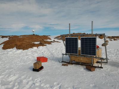
The Geodetic Observatory is based on continuous measurements of GNSS (Global Navigation Satellite System) data for the characterization of the neo-tectonics of a large area of the Northern Victoria Land. Particularly for the definition of a three-dimensional reference (plano-altimetric), and tidal waves, for the definition of a local and global absolute altimetric reference model. The permanent GNSS station 'LRSN', has been set on Mount Larsen (74° 57' 02,0" S - 161° 46' 10,1" E), 948 m a.s.l during the antarctic campaign 2015 - 2016. LRSN records data of GPS and GLONASS constellations, with an acquisition interval equal to 30 s. It is equipped with Tocpon Net-G3 GNSS receivers and chokering antennas, Topcon CR-G5 model (radome TPSH ), installed on steel pillars.
-
The project aims to estimate the current mass balance of glaciers and in particular of the Antarctic ice sheet by studying the space-time variations of the balance of snow accumulation through the integration of meteo-climatic and glaciological data. Analysis of weather-climatic and snow measurements collected by AWS stations (Dome C, C3, High Priestley, Talos Dome and a Nansen Ice Sheet) using sensors for measuring snow transport and measuring poles. Snow radar data collection of the Dumont d’Urville-Dome C traverse. Analysis of the chemical and isotopic composition of the collected snow samples. Analysis of satellite data to define the path of the Talos Dome-Dome C-Vostok-Dome B-Dome A crosspiece. High resolution chemical / isotopic analyzes (samples in trenches) for the study of post-depositional diffusion / re-emission processes that occur in the part of the snow closest to the surface. Study of the spatial variability of the snow accumulation at the TD site and along the ITASE traverse. Continuation of the analysis of the samples and geophysical data collected in the previous ITASE traverses.
-
The project is focused on the acquisition of data using the MZS_FRAD2008-02 interference filter radiometer, installed in November 2009 at Mario Zucchelli station, on the roof of the building OASI (74°41.6059' S 164°05.9423' E). The radiometer is active all year round and measures the global solar irradiance (watt / m2nm) at the values of 9 different wavelengths (about one spectrum per minute), where the filters are centered, and obtained from these the measure of the spectral irradiance with a resolution of 0.5 nm. The data is transferred to Italy on a daily basis via an Ethernet link. Data are acquired in the summer station of MZS from November 2009 to May 2013.
-
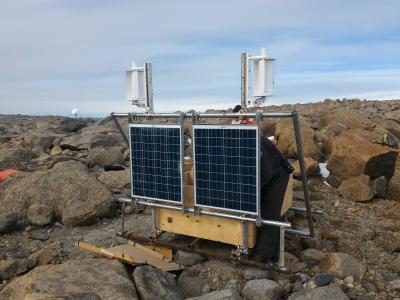
The Geodetic Observatory is based on continuous measurements of GNSS (Global Navigation Satellite System) data for the characterization of the neo-tectonics of a large area of the Northern Victoria Land. Particularly for the definition of a three-dimensional reference (plano-altimetric), and tidal waves, for the definition of a local and global absolute altimetric reference model. The permanent GNSS station 'INXP', has been set on Inexpressible Island (74° 56' 55,1" S - 163° 41' 06,3" E), 32 m a.s.l. during the antarctic campaign 2015 - 2016. INXP records data of GPS and GLONASS constellations, with an acquisition interval equal to 30 s. It is equipped with Tocpon Net-G3 GNSS receivers and chokering antennas, Topcon CR-G5 model (radome TPSH ), installed on steel pillars.
-
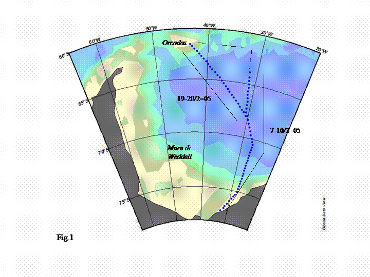
Collection of 451 temperature profiles with XBT and 35 profiles of temperature and salinity with XCTD probes in the Drake Strait, the Weddell Sea and between the northern tip of the Antarctica Paeninsula and the Orcadas Islands, to study of the variability of the Mixed Layer and the estimate of the heat content on the first 700 m of the water column, and the large scale representation of the surace and subsurface structure of the ACC. Three oceanographic cruises were performed on board of the Argentinean ice breaker “Almirante Irizar” in the three austral winters 2004-2005, 2005-2006 e 2006-2007. Data are acquired from the 7th of february and the sond were launched with a resolution of 20' of latitude to 70° ad 15' for higher latitudes, to better define the thermal southern front.
-
Objective of the project is to develop and test acoustic methodologies for the long-term monitoring of environmental variability in the Antarctic regions, through underwater acoustic oceanography experiments. Using passive and active acoustic systems is possible obtain the remote observation of air-sea-ice interaction processes in polynya areas in the Terra Nova Bay (74 ° 40′59.99 "S 164 ° 04′00.01" E). Acoustic measurements are carryed out by launching an oceanographic mooring supporting a 300 kHz broadband ADCP and CTD probes (temperature, conductivity and pressure sensors), left in the area until the following year's campaign.